InSAR is a powerful technology for monitoring deformation over a large area with high precision. We are pleased to announce that we have added native integration for InSAR data collected by all the major providers. User friendly tools for loading and querying this data make it a valuable addition to our GeoExplorer software.

News ![]() InSAR Data Integrated Into GeoExplorer
InSAR Data Integrated Into GeoExplorer
InSAR Data Integrated Into GeoExplorer
December 19, 2014

GeoExplorer
Continue reading

NavStar’s New Ultra Low-Power Monitoring Sensors
NavStar has released a new range of sensors that provide major benefits when compared to the conventional monitoring hardware.
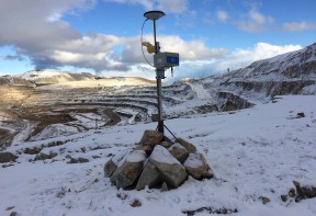
New GNSS Monitoring Sensor
NavStar’s GMS600 is a compact, high precision GPS/GNSS sensor that provides accurate three-dimensional displacement and tilt measurements for deformation monitoring.
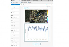
GeoExplorer Advanced Reports Module
GeoExplorer's Advanced Reports Option allow you to present that information on customized templates that can easily be updated, reproduced and shared.